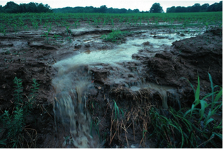
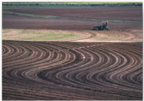
 (Source: http://indianapublicmedia.org/eartheats/government-underestimating-farmland-erosion/)
 A lot in Permaculture is about restoring ecosystems' health and as for any agroecosystem, that means starting with regenerating the health of the soil. Franklin Roosevelt once said "The nation that destroys its soil, destroys itself.". Yet in agriculture we often burn our soil, bare it, rip it and disturb it. We deplete this precious resource by turning it into gas or letting it wash or blow away. But why is soil erosion worrisome if it is a natural process that has shaped the Earth for billions of years? The problem is accelerated erosion due to human land use changes: whereas natural erosion is in the order of 0.1t/ha/year, worldwide erosion on cropland averages about 30t/ha/year (Pimentel et al., 1995). This is particularly troublesome for agriculturalists: when soil is washed away and it is not replenished, land becomes unproductive. It is estimated that 10 million ha of cropland worldwide are abandoned every year due to lack of productivity caused by soil erosion (Pimentel et al., 1995).
| Soils around the world develop at various rates depending on the intensity of various factors: the parent material, the topography, the climate and organisms (of all kingdoms!) over a period of time. However soil scientists agree that it takes at least 100 years to form an inch of topsoil (NRCS, n.d.). You will learn more about soil forming processes during our Permaculture Design Certificate courses (PDC) , but for now, I want to introduce you to a technique that promises reducing soil erosion in undulating farmland: the Keyline Pattern of Cultivation. In the mid 1900’s, Australian Percival A. Yeomans became very interested in soil biology as he noticed the importance of soil life processes for conservation. He worked in the gold and tin mining industry as an earthmoving contractor. Cheap storage and transportation of water over long distances are essential for a gold mine's success and Yeomans knew that it also meant the lifeblood of successful farming in semiarid Australia. With the eye of a mining geologist, he understood underlying geological structures and he used his keen appreciation of undulating and semiarid land to improve the use of water resources in his farm and combat desertification. |
Yeomans came up with a design system for land development called “Keyline Design” with the aim of improving water resources use and soil fertility. Planning and managing land with Keyline Design requires considering water management as paramount and having a close understanding of topography. (Keyline Design is covered in PDCs when learning about water harvesting). Keyline Design uses a planning concept called "The Scale of Permanence" which helps prioritize designing steps based on the relative permanence of land elements. In accordance to this scale, studying first climate/ rainfall patterns and topography of the land allows to then layout in order: water works (e.g. diversion channels, dams, reservoirs, dikes and gravity fed irrigation channels), roads, trees, buildings and subdivisions (fencing). The placement of one element follows the next one and so on. The resulting arrangement of elements harvests water and limits soil erosion.
Keyline Design includes a cultivation technique called “Keyline Pattern of Cultivation” which refers to a form of breaking up the soil in preparation for sowing and planting that beneficially alters the flow of runoff.
You may have heard of "Keyline Plowing" instead, which is plowing with a subsoiler (a deep ripper) and following the keyline pattern of cultivation. However the machinery used, the depth of its shanks and the timing of its use are dependent on factors that change according to the location and time of year. For example, using a certain machinery may only be appropriate given certain soil characteristics such as its moisture or structure.
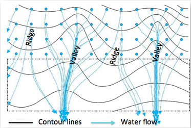
To understand the keyline pattern of cultivation, it is imperative to understand how runoff naturally moves in the landscape with the help of a few topographic features: contour lines, ridges and valleys.
Contour lines are imaginary lines in the landscape joining points of equal elevation on a surface. The pattern of black contour lines shown in the topographic map below help us visualize in a two-dimensional plan where the ridges and valleys are. It is crucial to grasp that gravity forces water to flow downhill, perpendicular to the contour lines. This causes runoff to be quickly drained out of the ridges and concentrate into the valleys. Ridges erode and soil accumulates in lower parts of the valleys.
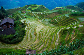
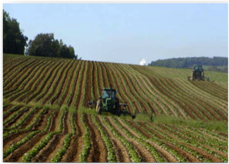
| To balance this uneven water flow and to retain water and soil, contour farming has been practiced for thousands of years. Man made terraces are the best example of contour farming without heavy machinery in hilly or mountainous terrain. For example Balinese stepped rice paddies are more than 2000 years old and Longji rice terraces in China in the picture to the right are 500 years old. In undulating and mechanized farmland, it is commonly suggested to practice contour farming to reduce erosion. This practice refers to cultivating with heavy machinery following a contour line as a guide and driving it parallel to that line back and forth as in the picture bellow. But machinery cultivates in parallel lines for space efficiency and contour lines are not parallel, so cultivating in parallel lines will inevitably lead to rip lines that are off contour and the tracing will have to be readjusted. |
Keyline pattern of cultivation is not contour farming as it is commonly misunderstood: while contour farming plows following any contour line as a guide, the keyline pattern of cultivation follows a specific contour line as a guide: the keyline.
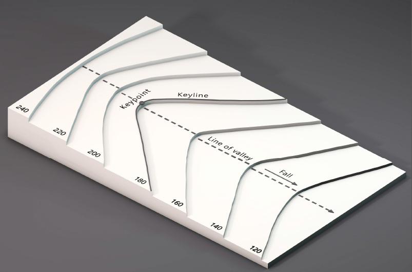
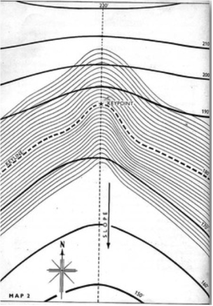
The keyline is the contour line within a primary valley that goes through the keypoint, and the keypoint is the point in primary valleys where the slope goes from convex to concave, where the steeper slope of the valley becomes flatter.
The Keyline pattern of cultivation, is such that the land is cultivated along parallel lines both below and above the keyline.
| The resulting pattern is composed of off contour rip lines that loop higher in valleys and lower in ridges. This pattern optimizes water retention in ridges while preventing excessive water accumulation in valleys. In heavy rainfall events, surface runoff moving downhill (perpendicular to contour lines) will be captured by the furrows, slowed down and more likely to infiltrate into the soil. If flooded, the furrows may act as mini diversion drains, helping redirect runoff towards ridges from higher points in adjacent valleys. |
Yeoman saw extremely accelerated soil formation in his Yeobarnie Farm designed according to the Keyline Design including the scale of permanence, keyline plowing and the keyline pattern of cultivation. These are terms that are often interpreted together as "Keyline Design" or simply "Keyline", but in this post I wanted to differentiate them for a cleared understating of the concepts within Keyline Design.
To my knowledge, there have been very few attempts at analyzing the effects of different practices within Keyline Design with a rigorous scientific method (See On Pasture's article). High rates of top soil formation acclaimed by its proponents (Yeoman's himself and Keyline Design educators around the world) tend to appeal the attention of many of us worried about soil erosion and interested in water harvesting. However there are no peer reviewed journal style articles available online to validate nor refute accelerated top soil formation due to any of the practices of Keyline Design. Keyline practitioners should recurrently gather data about various soil characteristics where initial and controlled conditions are carefully noted to advance the knowledge related to Keyline Design. Through research and sharing results, nuances regarding of the appropriateness of Keyline Design practices will continue to inform us for the benefit of all.
By Anna Zisa. Please contact if you have any data to share. Comments below are all welcome!
References
Pimentel, D, Harvey, C, Resosudarmo, P., Sinclair, K. et al. 1995. Science 267.5201. Retrieved from: http://science.sciencemag.org.proxy3.library.mcgill.ca/content/sci/267/5201/1117.full.pdf
Natural Resources Conservation Service. USDA. Soil Formation. Retrieved from: http://www.nrcs.usda.gov/wps/portal/nrcs/detail/wa/soils/?cid=nrcs144p2_036333

 RSS Feed
